WEEK 5 | Brief & Research
Brief
Background
The Wyre Forest District in Northern Worcestershire is an area with some of the most attractive
and diverse countryside in the heart of England. The district includes the towns of
Kidderminster, Stourport and Bewdley as well as surrounding villages and rural areas. It also
includes the Wyre Forest itself which is one of the largest intact semi-ancient woodlands in the
UK, extending to nearly 7000 acres. The River Severn, the longest river in Britain, runs
through the area.
There is already a short circular cycle route from the Wyre Forest Visitors Centre which is
signed for visitors. This is quite hilly but those who prefer a flat off-road route can cycle
through the Forest on Sustrans Route 45 along the route of an old railway line, starting from
Dry Mill Lane car park near Bewdley.
We now plan to promote several other safe cycle routes in the Wyre Forest area which families
can explore, following the routes either using a leaflet or on their smartphones. The brief is
therefore real and ‘live’ and would ordinarily have been handed out to a commercial design
company. You are involved in concept designs for the initial phase - which will realistically be
limited by the time available and trimmed to suit your own abilities on this design module.
The Client
Your client for this project is the Wyre Forest Cycle Forum. The Forum encourages safe cycling
in the Wyre Forest district area, for example by running adult cycle training, promoting local
cycling routes and putting forward recommendations to make roads and cycle paths safer for
cyclists.
Leaflets from site:
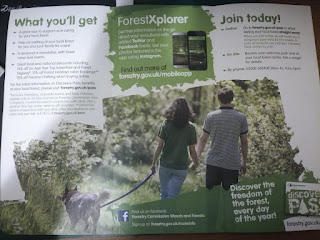
= very family oriented, supported by pictures of people/families/dogs in nice environment. Green works as a calming colour - connected to the nature. Overall fits well within the audience


=catches the attention of dog owners, big, high quality, appealing pictures are a big main features of these leaflets (=make pictures priority) earthy colour palette seems to work with
Colour Palettes Options
-based of the leaflets and signs all around the site, I've noticed that earthy, not too dull colours work well within this audience and place
=earthy colour palette examples:
Teme Valley Trail
https://www.visitthemalverns.org/wp/wp-content/uploads/2017/05/Teme-Valley-Trail-Guide-Leaflet.pdf
https://www.visitthemalverns.org/wp/wp-content/uploads/2017/05/Teme-Valley-Trail-Broadheath-Walk-Trail.pdf
-another earthy colour scheme that works well for the subject
-there's a bit too much photos, some of them overlapping = one or few clear photos seem like a better solution as seen in the Wyre Forest leaflets. One bigger photo makes it more clear and eye-catching
The Peak District
http://www.gooutdoors.co.uk/blog/wp-content/uploads/Peak-District-Cycle-Routes.jpg
-very clean design, really easy to find your way through and orientate
-works really well with only vector graphics = easy to recognize
The Route 45
https://www.sustrans.org.uk/ncn/map/route/route-45
National Route 45 of the NCN links Chester with Salisbury via Whitchurch, Ironbridge, Bridgnorth, Droitwich Spa, Worcester, Gloucester, Cirencester and Swindon.
The full route travels 270 miles from Chester to Salisbury and takes you via Shrewsbury, Bridgnorth, Worcester, Gloucester, Stroud, Cirencester and Swindon.
Through Wiltshire, National Route 45 links Swindon to Salisbury via the World Heritage site at Avebury and crosses the North Wessex Downs and Salisbury Plain. North of Swindon Route 45 traverses the Cotswold Water Park on bridleways (which can be muddy in wet weather), to swing across the high plateau of the Cotswold Hills to the ancient Roman town of Cirencester. After this it travels down the escarpment to Nailsworth and via traffic free railway paths and canal towpaths to Stroud and Eastington before joining Route 41 at Saul on the Sharpness Canal.
The section of Route 45 between Worcester and Droitwich is very popular and follows some quiet lanes and the towpath of the Worcester and Birmingham Canal to link Worcester and Droitwich on the eastern side. This section is only 10 miles and flat, making it perfect for the inexperienced rider. For the return journey Route 46 provides an on-road alternative to the western side, leaving Worcester at the racecourse and following a similar line to the Droitwich Canal.
After Droitwich the route continues on to Stourport-on-Severn, Bridgnorth, Whitchurch and then Chester.
Moodboard/Inspiration/Leaflets:


Comments
Post a Comment